Introduction
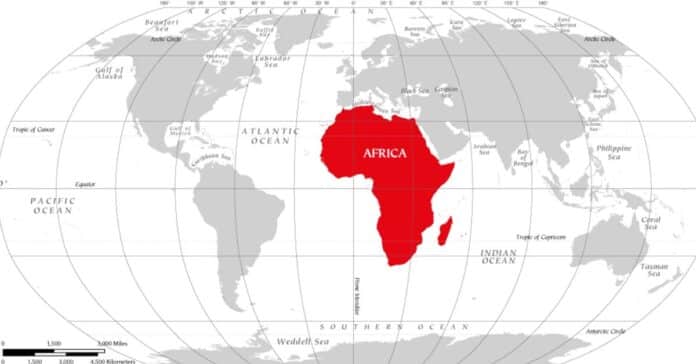
On August 19, 2025, the African Union officially endorsed the initiative Correct The Map, promoted by the organizations Africa No Filter and Speak Up Africa. This campaign, which proposes replacing the traditional Mercator projection with the Equal Earth projection introduced in 2018, aims to restore Africa’s true geographical and symbolic dimensions. Far from being a mere technical matter, this decision represents a political and cultural act of broad significance: to redraw the world map is to rethink power relations, to challenge epistemic hierarchies, and to affirm Africa’s role in shaping global narratives.
Cartographic Distortion as a Colonial Legacy
The representation of geographic space has never been a neutral act; rather, it reflects political, cultural, and cognitive choices with long-term consequences. The Mercator projection, introduced in 1599 by the Flemish cartographer Gerardus Mercator to facilitate maritime navigation, is emblematic of this dynamic. While it provided a useful technical tool for plotting straight-line sea routes, it also generated distortions that helped consolidate a hierarchical vision of the world. On Mercator maps, Africa appears much smaller than it truly is, while Europe and North America are magnified. This visual imbalance reinforced the colonial imagination of a “center” and a “periphery,” legitimizing centuries of domination by portraying Europe as large, central, and technologically advanced, while Africa was diminished both in scale and in symbolic value.
Equal Earth and the Challenge of Epistemic Justice
The initiative led by Africa No Filter and Speak Up Africa through the adoption of the Equal Earth projection belongs to a broader debate on epistemic justice and the decolonization of knowledge. Equal Earth, introduced in 2018 by Bojan Šavrič, Tom Patterson, and Bernhard Jenny, was designed to represent continents in more faithful proportions, thereby highlighting the true vastness of Africa, the second largest continent on the planet—over fourteen times the size of Greenland and nearly twice the size of Europe. This is not merely a technical correction, but an act of symbolic reparation: by showing Africa as it really is, the projection challenges centuries of cartographic marginalization. The debate around Equal Earth resonates with broader intellectual currents that seek to democratize knowledge, dismantle Eurocentric biases, and build new epistemologies in which the Global South is no longer portrayed as a minor appendix of world history but as a central agent of its future.
Maps, Power, and Africa’s Future on the Global Stage
The African Union’s decision is best understood within a broader context in which the continent seeks to redefine its role in the global order, demanding greater voice in international forums ranging from climate negotiations to reforms of economic institutions. Cartography thus becomes a tool of symbolic diplomacy: correcting maps is a way to contest the centuries-old perception of Africa as “too small” and to reaffirm its centrality. It is significant that institutions such as the World Bank and NASA have already adopted alternative projections, acknowledging the political implications of how the world is drawn. For Africa, embracing Equal Earth signals not only a cultural repositioning but also an assertion of agency: to redraw the map is to redraw the terms of participation in global governance. Far from being a matter of aesthetics or pedagogy, this choice speaks to the core of Africa’s long struggle for recognition, representation, and justice in the international system.
References
Harley, J. B. The New Nature of Maps: Essays in the History of Cartography. Baltimore: Johns Hopkins University Press, 2001.
Makura, Moky. “Correct the Map: Africa and the Fight for Representation.” Africa No Filter Reports, 2025.
Monmonier, Mark. Rhumb Lines and Map Wars: A Social History of the Mercator Projection. Chicago: University of Chicago Press, 2004.
Ndiaye, Fara, and Selma Malika Haddadi. “Cartography and African Identity: Beyond Mercator.” Journal of African Geopolitics 12, no. 2 (2025): 45–68.
Snyder, John P. Flattening the Earth: Two Thousand Years of Map Projections. Chicago: University of Chicago Press, 1993.

